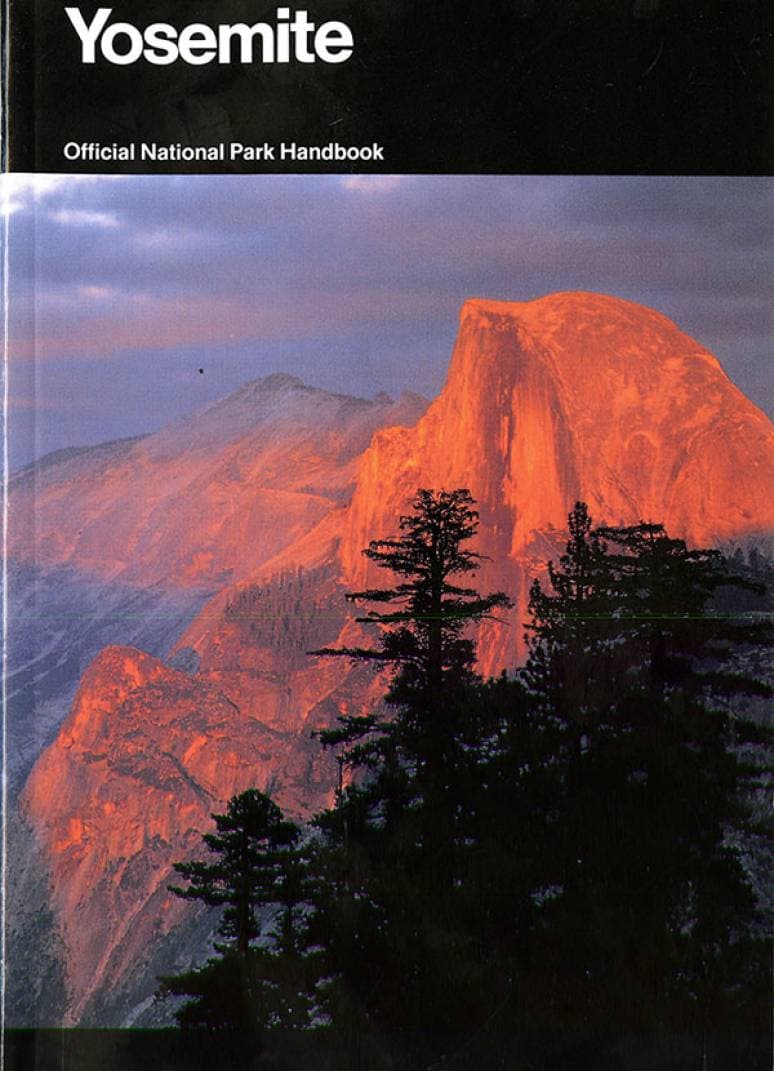
Cover: Owachomo Bridge.
Natural Bridges NATIONAL MONUMENT · UTAH
UNITED STATES DEPARTMENT OF THE INTERIOR Douglas McKay, Secretary NATIONAL PARK SERVICE, Conrad L. Wirth, Director
Three gigantic natural bridges carved out of sandstone and located in a region of superb scenery
San Juan County, in the southeastern corner of Utah, is a land of brilliantly colored cliffs, tortuous box canyons, pinnacles, and arches. Near the center of this scenic and geologic potpourri is Natural Bridges National Monument.
Within the monument are three huge natural bridges. While they are exceeded in size by the great Rainbow Bridge, which lies about 60 miles to the southwest in Rainbow Bridge National Monument, they rank with the largest known natural bridges.
One of these bridges—Owachomo—is directly across the 600-foot-deep Armstrong Canyon and spans the mouth of a short tributary canyon. The road from Blanding, Utah, ends at the rim of the Armstrong Canyon. To visit the other bridges in the monument, one must walk. The trail is unimproved, and sometimes rough, but the 6-mile hike is rewarded by views of the magnificent canyons, the bridges, and ancient Indian ruins.
The headquarters area of the monument overlooks the Owachomo Bridge, and a 300-yard trail drops to the bottom of Armstrong Canyon to a point where one can walk under the bridge. Continuing on this trail, Sipapu Bridge may be reached by a 3-mile walk; however, if you wish to see all three bridges with the least walking, drive your car from headquarters, 4½ miles, to the Kachina Bridge parking area and from there it is three-quarters of a mile by a ladder trail to Kachina Bridge and 2 miles from Kachina to Sipapu Bridge, up White Canyon. No trail is maintained between Kachina Bridge and Owachomo Bridge.
The Bridges and Their Names
The bridges were first seen by white man in 1883 when Cass Hite, a prospector, visited the region. National publicity was given to the area in 1904 when an illustrated article appeared in the National Geographic Magazine. In 1908 the area was proclaimed Natural Bridges National Monument by President Theodore Roosevelt. This action was the result of pleas of Utah citizens and of a Government surveyor that the bridges be protected by the Federal Government.
Owachomo is in view at the end of the road.
Early explorers had named the bridges for members of their parties or for relatives. When the monument was established, an effort was made to find Indian names which would fit the 2 bridges. Paiute Indians, who still live in the country, had no names for the individual bridges. At the time they were questioned they professed to know only a single term which they applied to all bridges, natural or otherwise. This was “Ma-Vah-Talk-Tump,” or “Under the Horse’s Belly.”
Kachina Bridge—the youngest of the three.
At that time it was generally thought that the prehistoric people who had lived in the ruins of southern Utah were direct ancestors of the Hopi Indians, so it was natural, when no Paiute names were forthcoming, that Hopi names were applied to the bridges. They are:
Owachomo (Rock Mound)—So named because of a large, rounded block of rock on the mesa near one end of the bridge. Also formerly known as the Edwin Bridge.
Kachina—On one of the abutments of this bridge are numerous prehistoric pictographs, some of which resemble Hopi masked dancers, or kachinas. The former name for this bridge was Caroline.
Sipapu—The graceful arch of this bridge suggested to its namers the sipapu (place of emergence), a hole through which the Hopi believe their ancestors emerged from a lower, dark world into the present, sunlit one. This was also known as the Augusta Bridge.
The dimensions of the bridges are:
How Natural Bridges Are Made
To make a natural bridge Mother Nature must have several ingredients: a proper stone that 3 will shape well (a cross-bedded sandstone is best), a slowly rising landscape, and a desert-type stream that occasionally will scour its bed with a tremendous head of water and sand. All these were present in southern Utah.
The stone of the Natural Bridges area is a cross-bedded grey sandstone, known as the Cedar Mesa sandstone. It is of Permian age and similar in appearance and structure to the more recent Navajo sandstone in which so many caves and arches have been formed.
When the land began to rise slowly from its ancient sea bed, two small streams formed on the western slopes of the Elk Ridge. The streams are known today as White River and Armstrong Creek, its tributary. They made meandering channels across the flat land and gradually entrenched themselves into tortuous canyons. As the land continued to rise, the streams cut ever deeper canyons.
The main purpose, or the driving force, of a stream is to make the shortest distance between two points, that is, a straight line. Every creek and river attempts to make a straight channel with an even grade from its source to its mouth. Hills, ridges, blocks of rock, or any other obstacles which a stream must bypass are gradually worn away as the stream makes a channel more to its choice.
The tortuous streams in their deep rock channels were constantly trying to straighten their courses. During floods the silt-laden waters were thrown with great force against the walls of the meanders. In several places the fins of rock around which the windings of the streams passed were so thin that during the course of many centuries of buffeting the rock gradually wore away and a hole was bored through the fin. The waters poured through the gap and the bridge was born. After the initial breach was made, the stream continued to enlarge the opening and to cut its channel still deeper. Eventually, the old meander was left high and dry as a “fossil” stream bed.
Ages of the Bridges
Several phases of bridge-making may be seen at Natural Bridges National Monument.
Kachina Bridge is a new bridge. It is huge and bulky, and has a comparatively small opening. White River is still actively enlarging the opening beneath the span.
Sipapu Bridge is mature. It is a graceful, symmetrical span, and its abutments now lie far enough from the stream bed that the river has little or no cutting action on the rock.
Sipapu Bridge, looking up White Canyon.
Owachomo Bridge is in its old age. It suffers no erosion from the stream; only the slight erosion from rains, frost action, or wind-blown sands now attack its surface. The life expectancy of Owachomo is short compared with that of the other two; it may span the canyon for centuries yet, or the crack which will ultimately cause its collapse may already have started.